Hiking the Laugavegur Trail: A Beginner's Guide to Iceland's Highlands

What Is the Laugavegur Trail and Why Do Hikers Flock to It?
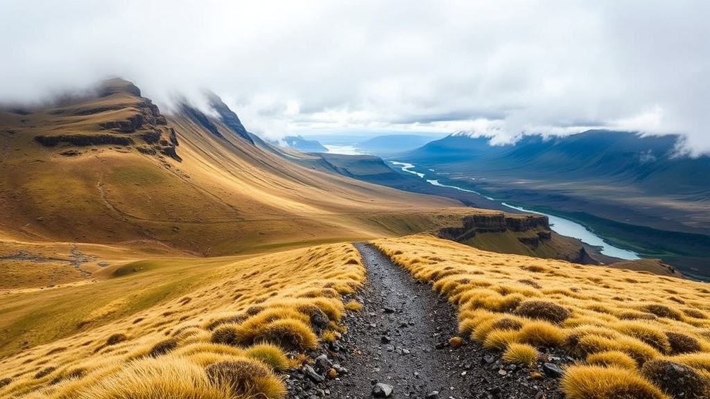
The Laugavegur Trail is a 55-kilometer (34-mile) trekking route through Iceland's southern highlands, connecting the rhyolite mountains of Landmannalaugar to the lush glacial valley of Þórsmörk. This post breaks down everything a beginner needs to know—timing, difficulty, gear, huts versus camping, costs, and safety—so you can plan a confident first crossing of one of Europe's most spectacular long-distance paths. The highlands don't forgive poor preparation. That said, the trail rewards anyone who shows up with the right expectations and a solid plan.
The scenery shifts every few hours. One moment you're walking past neon green moss fields and obsidian lava flows; the next, you're staring at turquoise lakes and ice-capped peaks. It's not a stroll through a park. River crossings, sudden weather swings, and exposed ridges are part of the package. But for hikers who want a genuine wilderness experience without technical climbing, this is the sweet spot.
When Should You Hike the Laugavegur Trail?
The best window is late June through early September, with mid-July to August offering the most stable conditions and fully open mountain huts. Outside this window, snow can bury trail markers, rivers run higher and colder, and emergency services have limited reach. The Icelandic highlands are not a year-round playground for casual trekkers.
July brings the warmest temperatures—daytime highs around 10–13°C (50–55°F)—but also the busiest huts. If you value quieter trails, late August and the first week of September can be magical. The autumn colors start creeping in, and the midnight sun has faded enough to let you sleep. The catch? Weather turns faster. You might get four seasons in one afternoon.
Always check SafeTravel.is before heading out. The Icelandic Association for Search and Rescue runs this site, and it posts real-time alerts on trail conditions, river levels, and wind warnings. It's not a suggestion—it's your first stop on planning day.
How Difficult Is the Laugavegur Trail for Beginners?
For a fit beginner with some overnight hiking experience, the Laugavegur Trail is challenging but entirely doable. The total distance is typically covered in four days, though strong hikers sometimes compress it into three. Daily elevation gain ranges from 300 to 600 meters, and the terrain includes loose volcanic gravel, snow patches, and knee-deep river crossings.
The mental challenge often outweighs the physical one. Visibility can drop to near zero in fog or driving rain. Trail markers (yellow-painted posts and wooden stakes) are spaced generously, but in whiteout conditions they disappear fast. Here's the thing: you don't need to be an athlete. You need to be steady, patient, and willing to turn back or wait out a storm if the conditions say no.
River crossings deserve respect. The water is glacier-fed—cold enough to numb your legs in under a minute. Some crossings are ankle-deep trickles; others reach mid-thigh after heavy rain. Unbuckle your hip belt before wading, use trekking poles for balance, and never cross alone if you can avoid it. Ferðafélag Íslands (the Icelandic Touring Association) maintains the huts and posts current river conditions at fi.is.
What Gear Should You Pack?
Icelandic weather has a reputation for a reason. Pack for wind, rain, and cold—even in August. Your shelter, sleep system, and rain gear are the non-negotiables.
For tents, the MSR Hubba Hubba NX is a proven choice among Laugavegur hikers. Its geodesic frame sheds wind well, and the 1.7-kilogram packed weight won't crush your shoulders. Pair it with a Therm-a-Rest NeoAir XTherm sleeping pad; the R-value of 6.9 insulates against cold, wet ground. For footwear, the Salomon X Ultra 4 GTX handles the mixed terrain confidently, though some trekkers prefer full leather boots for ankle support on the descents.
Here's a practical breakdown of shelter options:
| Option | Weight | Cost (approx.) | Best For |
|---|---|---|---|
| MSR Hubba Hubba NX tent | 1.7 kg | $450–$500 | Campers who want reliable weather protection |
| Hilleberg Niak tent | 1.2 kg | $700–$750 | Ultralight hikers prioritizing weight over space |
| FI hut bed | N/A | ISK 12,000–16,000 per night | Beginners who want dry gear and social warmth |
Other items worth carrying: a Katadyn BeFree water filter (streams are plentiful but livestock roam some valleys), merino base layers from Smartwool or Icebreaker, and a down jacket with at least 800-fill power. Don't skimp on gloves and a brimmed hat. The wind across Hrafntinnusker can feel like it's trying to peel your skin off.
Where Will You Sleep Along the Trail?
Most beginners stick to the hut system run by Ferðafélag Íslands, with stops at Hrafntinnusker, Álftavatn, Emstrur (Botnar), and Þórsmörk. These huts fill up fast—sometimes months in advance for July dates. Each hut has a warden, a kitchen, gas stoves for rent, and heated drying rooms that feel like paradise after a wet day.
If huts are booked, camping is permitted adjacent to each hut site for a lower fee. You still get access to the kitchen and toilets, but you'll be pitching in exposed terrain. At Hrafntinnusker, the ground is rocky and the wind howls all night. At Álftavatn, the grass is softer and the lake views are unreal. Worth noting: wild camping outside designated areas is discouraged and, in some parts of the highlands, prohibited to protect fragile moss and soil.
Þórsmörk is the traditional finish line, but many hikers extend two more days over the Fimmvörðuháls pass to Skógar. That extension is steeper, crosses fresh lava from the 2010 Eyjafjallajökull eruption, and demands solid weather. It's optional. Finishing in Þórsmörk is a respectable, complete path in itself.
How Much Does a Laugavegur Trek Cost?
A self-guided four-day trek typically runs between $800 and $1,500 USD per person, not including flights. The biggest variables are hut versus camping, gear ownership, and whether you book a luggage transfer.
Hut beds cost roughly ISK 12,000–16,000 per night (about $85–$115 USD). Camping at hut sites is closer to ISK 3,000–4,000 per night. The Highland Bus (operated by Reykjavík Excursions) charges around ISK 14,000–18,000 each way from Reykjavík to Landmannalaugar and from Þórsmörk back to the city. If you don't own a tent or sleeping bag rated to at least -5°C, rentals in Reykjavík add another $150–$250 for the week.
Food is another line item. Hut kitchens have basic cookware, but you must bring your own provisions. Pre-packaged dehydrated meals from brands like Real Turmat or LYO Food are popular on the trail—light, calorie-dense, and easy to prepare with boiling water. A four-day food supply costs $60–$100 depending on appetite. Some hikers mix in trail mix, rye bread, and dried fish from Bónus or Krónan supermarkets in Reykjavík to save money.
How Do You Get There and Back?
Most trekkers start in Landmannalaugar and finish in Þórsmörk, following the north-to-south route. This direction saves the steepest climb for day one (when legs are fresh) and finishes with a gentler descent into green valleys. The Highland Bus operates from Reykjavík's BSI terminal from roughly mid-June through mid-September. Book seats early—they sell out, especially in July.
If you're driving a rental car, be aware that standard 2WD vehicles are not allowed on F-roads (the mountain roads leading to the trailheads). You need a 4x4 with decent clearance, and river crossing insurance is a separate conversation with your rental company. For most beginners, the bus is simpler, cheaper, and far less stressful.
From Þórsmörk, you can catch the bus back to Reykjavík, or continue to Skógar and take a different bus from there. The schedule is tight, so build in buffer days. Missing the last bus means an unplanned night in the valley—or an expensive super-jeep taxi.
What Safety Rules Should Beginners Follow?
Never underestimate Icelandic weather. The catch? It looks fine at 9 a.m. and turns violent by 2 p.m. Check the Icelandic Meteorological Office forecast daily. If the forecast shows sustained winds over 15 m/s (33 mph) or heavy rain, consider waiting a day or taking a lower alternative route.
Leave your itinerary with someone who isn't on the trail. Carry a charged power bank, a paper map, and a whistle. The trail is well-trodden in summer, but fog can erase every visual cue. Trekking poles reduce knee strain on descents and provide stability in rivers. A personal locator beacon (PLB) or satellite messenger like Garmin inReach Mini 2 adds a serious safety net in areas with no cell coverage.
Finally, respect the environment. The moss you step on can take decades to recover. Stick to marked paths, use designated toilet facilities, and pack out every scrap of trash. The highlands have remained wild because past hikers showed restraint. You're walking in their footsteps—literally.